4D Volcano Tomography
Real-time 4D Volcano Tomography
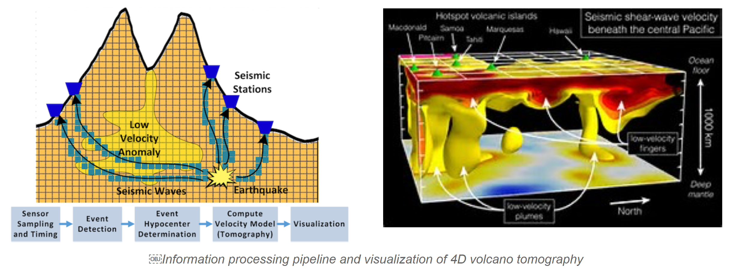
About 500 million people today live close to active volcanoes. However, traditional volcanic and earthquake instrumentation such as broadband seismometers is expensive (~$20,000/unit), difficult to install, and does not yet have the capability to recover physical dynamics with sufficient data resolution, limiting scientists’ ability to study and predict earth dynamics. We developed a new paradigm for imaging 4D (3D and time) tomography of active volcanoes using large-scale sensor networks [IPSN15, IPSN13, RTSS10, SECON13, TOSN13]. We designed new wireless sensor systems for real-time and long-lived volcano and earthquake monitoring, as well as new event detection, localization, and tomography algorithms.
Our solution is a fundamental paradigm shift from traditional data collection approaches in that it analyzes seismic data and computes real-time, full-scale three-dimensional fluid dynamics of complex structures like volcano conduit system within the active sensor network. In 2015, my group was invited to join a multi-national team led by University of North Carolina at Chapel Hill and MIT to deploy 16 seismic sensor stations developed by my group on a live volcano in Chile.
Funding
1. National Science Foundation, Cyber-Enabled Discovery and Innovation (CDI), "CDI: Collaborative Research: VolcanoSRI: 4D Volcano Tomography in a Large-Scale Sensor Network",
PI, $1,833,608 (MSU portion $517,589), 2011-2016.
2. National Science Foundation, "CAREER: Design and Analysis of Performance-Critical Wireless Sensor Networks: A Fusion-Centric Approach", PI, $424,673, 2010-2016.
People
Guoliang Xing (PI, Professor, CUHK)
Rui Tan (Postdoc, currently Assistant Professor at Nanyang Technological University, Singapore)
Jinzhu Chen (Ph.D 2015, currently with GM Research)
Dennis Phillips (Ph.D candidate, MSU)
Mohammad-Mahdi Moazzami (Ph.D candidate, MSU)
Collaborators
Wenzhan Song (Professor, ECE, University of Georgia)
Jonathan M. Lees (Professor, Geological Sciences, UNC Chapel Hill)
Awards & Recognitions
- Best Paper Finalist, “Imaging Volcano Seismic Tomography in Sensor Networks”, the 10th Annual IEEE Communications Society Conference on Sensor and Ad Hoc Communications and Networks (SECON), 2013.
Publications
- Mohammad-Mahdi Moazzami, Dennis Phillips, Rui Tan, Guoliang Xing, ORBIT: a Smartphone-based Platform for Data-intensive Embedded Sensing Applications, Proceedings of the 14th International Conference on Information Processing in Sensor Networks (IPSN), 2015, acceptance ratio: 27/111=24%.
- Liqun Li, Guoliang Xing, Limin Sun, Wei Huangfu, Ruogu Zhou, Hongsong Zhu, Exploiting FM Radio Data System for Adaptive Clock Calibration in Sensor Networks, the 9th International Conference on Mobile Systems, Applications, and Services (MobiSys), June 28-July 1, Washington DC, USA, 2011, acceptance ratio: 25/141 = 17.7%.
- Rui Tan, Guoliang Xing, Jinzhu Chen, Wenzhan Song, Renjie Huang, Quality-driven Volcanic Earthquake Detection using Wireless Sensor Networks, The 31st IEEE Real-Time Systems Symposium (RTSS), November 30-December 3, 2010, San Diego, CA, USA.
- Lei Shi, Wen-Zhan Song, Mingsen Xu, Qingjun Xiao, Jonathan M. Lees, and Guoliang Xing , Imaging Volcano Seismic Tomography in Sensor Networks, The 10th Annual IEEE Communications Society Conference on Sensor and Ad Hoc Communications and Networks (SECON), 2013, acceptance ratio 29%: 51 out of 173, Best Paper Candidate.
- Guojin Liu, Rui Tan, Ruogu Zhou, Guoliang Xing, Wen-Zhan Song, Jonathan M Lees, Volcanic Earthquake Timing using Wireless Sensor Networks, Proceedings of the 12th International Conference on Information Processing in Sensor Networks (IPSN), 2013, acceptance ratio: 24/115 = 20.9%.
- Anwar Saipulla, Benyuan Liu, Guoliang Xing, Xinwen Fu, Jie Wang, Barrier Coverage with Sensors of Limited Mobility, The 11th ACM International Symposium on Mobile Ad Hoc Networking and Computing (MobiHoc), Chicago, USA, September 2010.
- Rui Tan, Guoliang Xing, Xue Liu, Jianguo Yao, Zhaohui Yuan, Adaptive Calibration for Fusion-based Wireless Sensor Networks, The 29th Conference on Computer Communications (INFOCOM), March 15-19, 2010, San Diego, CA, USA, acceptance ratio: 276/1575=17.5%.
- Mohammad-Mahdi Moazzami; Dennis E. Phillips; Rui Tan; Guoliang Xing, ORBIT: A Platform for Smartphone-Based Data-Intensive Sensing Applications, IEEE Transactions on Mobile Computing, in press.
- Rui Tan, Guoliang Xing, Zhaohui Yuan, Xue Liu, Jianguo Yao, "System-level Calibration for Data Fusion in Wireless Sensor Networks", ACM Transactions on Sensor Networks (TOSN), 9(3), May 2013.
Research Thrusts
1. A Sensor Network for Real-Time Volcano Seismic Monitoring: System Design, Field Deployment and Lessons Learned. Volcano tomography provides valuable information concerning the internal structure of a volcano. Current techniques utilized by seismologists only provide a static snapshot of this structure. During times of increased activity being able to obtain a real-time images of the interior would allow seismologists to better understand volcanic dynamics. We develop a seismic monitoring sensor network featuring in-network processing of the seismic signals with the capability to perform volcano tomography in real-time. The design challenges, analysis of processing/network processing times in the information processing pipeline, the system is designed to meet these challenges and validated from deploying a prototype network on two volcanos in Ecuador and Chile. Our study shows that it is possible to achieve in-network seismic event detection and real-time tomography using a sensor network that is 2 orders of magnitude less expensive than traditional seismic equipment.
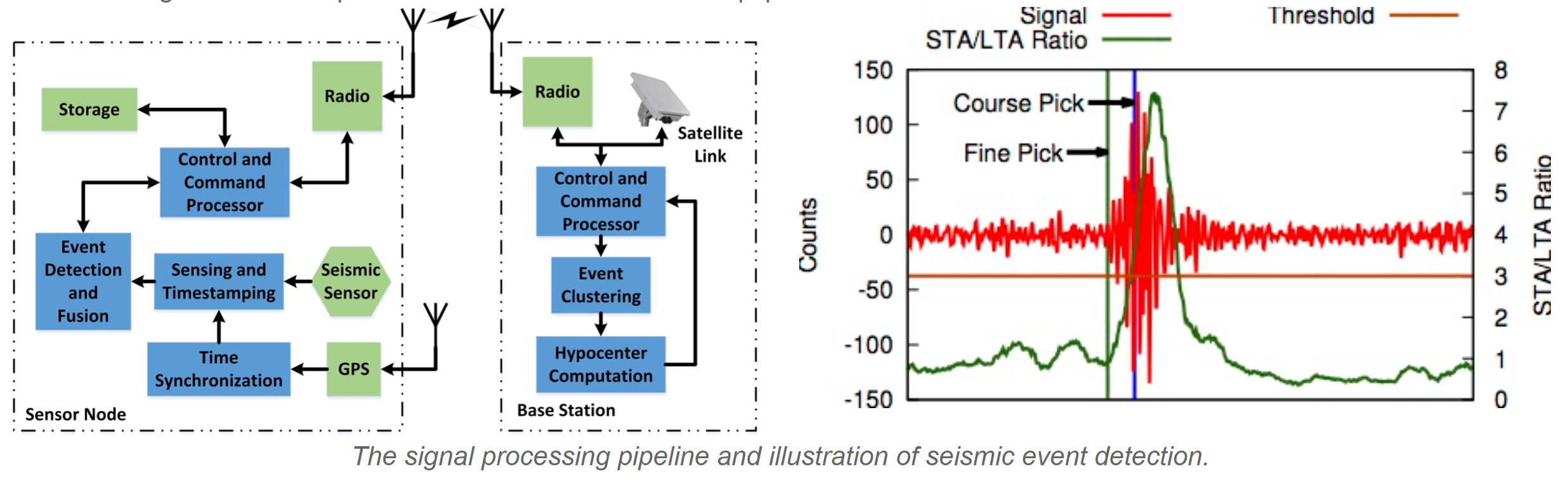
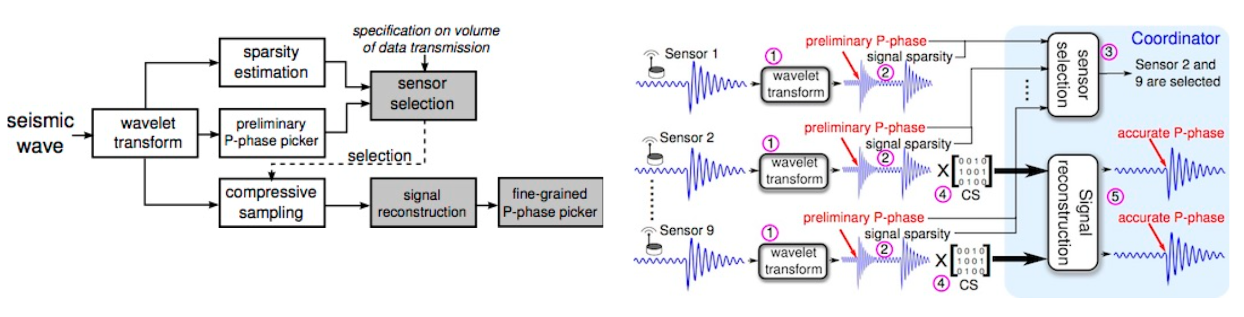
2. Volcanic Earthquake Timing Using Wireless Sensor Networks. Recent years have witnessed pilot deployments of inexpensive wireless sensor networks (WSNs) for active volcano monitoring. We study the problem of picking arrival times of primary waves (\ie, P-phases) received by seismic sensors, one of the most critical tasks in volcano monitoring. Two fundamental challenges must be addressed. First, it is virtually impossible to download the real-time high-frequency seismic data to a central station for P-phase picking due to limited wireless network bandwidth. Second, accurate P-phase picking is inherently computation-intensive, and is thus prohibitive for many low-power sensor platforms. To address these challenges, we propose a new P-phase picking approach for hierarchical volcano monitoring WSNs where a large number of inexpensive sensors are used to collect fine-grained, real-time seismic signals while a small number of powerful coordinator nodes process collected data and pick accurate P-phases. We develop a suite of new in-network signal processing algorithms for accurate P-phase picking, including lightweight signal pre-processing at sensors, sensor selection at coordinators as well as signal compression and reconstruction algorithms. Testbed experiments and extensive simulations based on real data collected from a volcano show that our approach achieves accurate P-phase picking while only 16% of the sensor data are transmitted. Our approach can be readily applied to a broad class of high-precision event timing applications in resource-constrained WSNs.
Field Deployments
My group has developed and deployed over 20 sensor stations on two live volcanoes in Ecuador and Chile, in 2012 and 2015 respectively. By working with leading earth scientists, we are making the data gathered from these deployments as well as the system prototypes available to the volcanology and seismology communities.
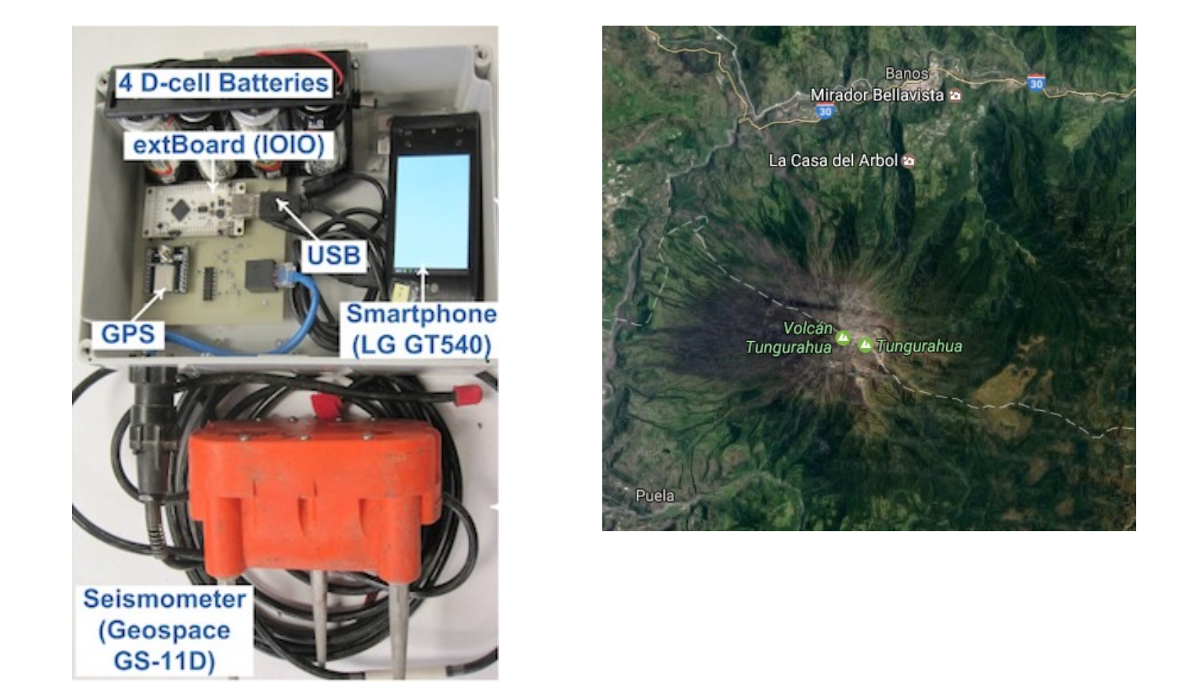
1. Tungurahua Deployment To test the first generation sensor nodes, we traveled to the Tungurahua Volcano near Baños Ecuador and deployed six nodes in July, 2012. Tungurahua is a stratovolcano located 140 kilometers south of the capital Quito and one of the major volcanos of Ecuador. This field trip afforded us an opportunity to test under real field conditions. It also allowed us to gain first-hand experience of the conditions we would face in future larger scale deployments. The primary goal was to test whether our sensing hardware can record seismic signal. The field deployment was supported by Mario Ruiz of the Instituto Geofísico de la Escuela Politécnica Nacional in Quito.
Participants in this deployment included:
Dr. Jonathan Lees, University of North Carolina, Chapel Hill
Dr. Guoliang Xing, Michigan State University
Dr. WenZhan Song, Georgia State University
Dennis Phillips, Michigan State University
Daniel Bowman, University of North Carolina, Chapel Hill
Keehoon Kim, University of North Carolina, Chapel Hill
Lei Shi, Georgia State University
The six prototype sensors deployed each consisted of an Android phone with an attached external board. The external board contained a 12 bit digitizer, signal amplifier and GPS receiver controlled by software running on the phone. Two of the sensors were deploy adjacent to the RUNTUN permanent monitoring stations. The RUNTUN station is located next to La Casa del Arbol. Two additional sensors were deployed approximately 1 km from the station to the east while the final two sensors were deployed several kilometers away to the west on the other side of the adjacent ridge. During the 5-day deployment period the sensors near the RUNTUN station were able to successfully record a seismic event 20km away.
The deployment faced several challenges. The first was the remote location. Only a few sites were accessible by road. Vast areas were only reachable via hiking on foot. Utilizing helicopters to assist during deployment was not feasible due to the altitude and the highly variable nature of the weather conditions.
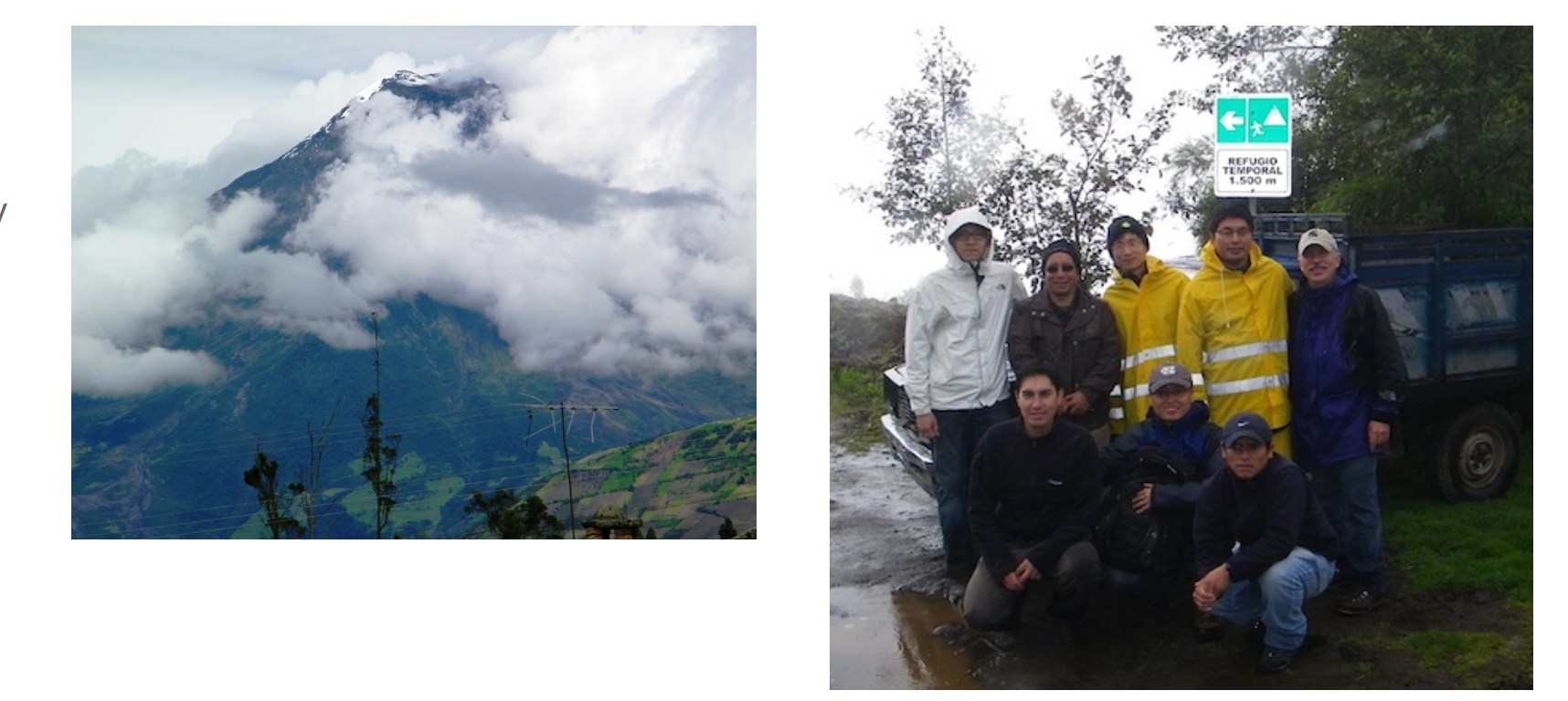
Besides the distances that must be covered, working at high altitude (12,000 to 14,000 feet) presented its own challenges. From the sensor design standpoint, care must be taken to minimize the package weight. It was important for the teams to be able to maximize the number of packages carried on each trip so as to minimize the number of trips. The wet weather conditions presented the second challenge. Between fog, that commonly covered the volcano, and rains challenged the equipment packaging.
During this field trip, we experienced several of these challenges. During the first two days, the volcano was covered in fog and it rained heavily. This was a good test for the packages and the team. After two days under these conditions, the sensors were still functioning and were completely dry inside. Subsequently, it was discovered that the cases used were not strong enough to withstand rough handling.
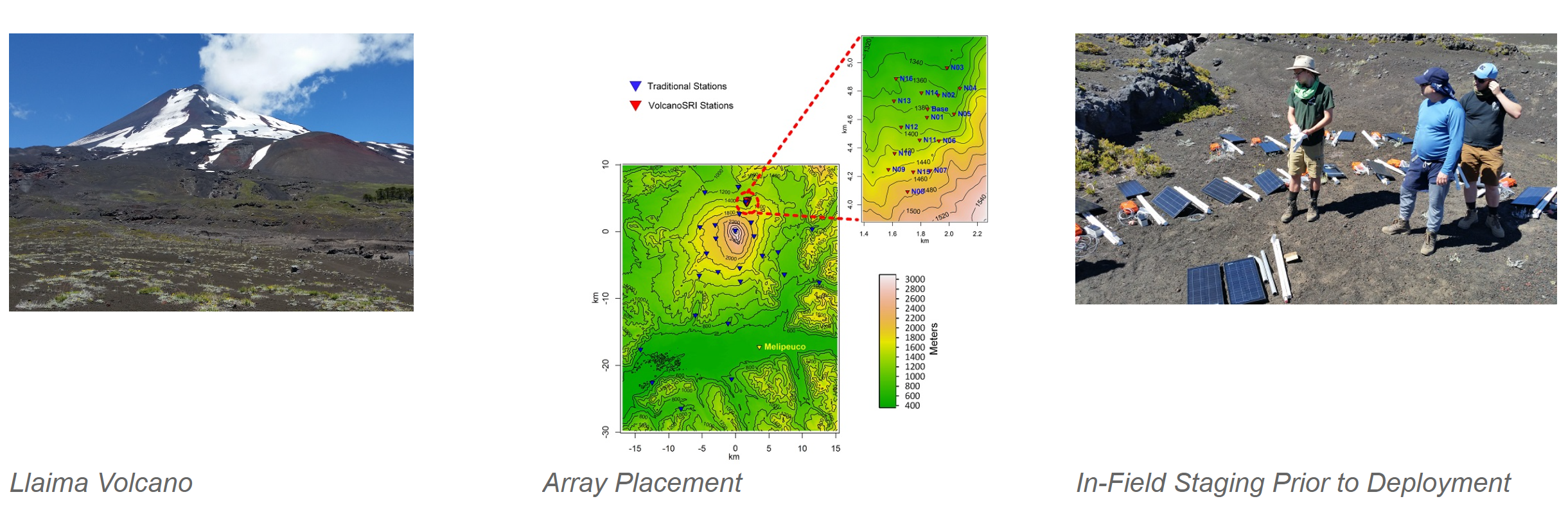
2. Llaima Deployment
The second deployment was on Llaima Volcano located near Melipeuco, Chile.
Llaima is one of the most active volcanos in Chile and is located 663 km southeast of Santiago.
The primary goal of this deployment was to test the new generation of hardware over a long duration period.
We deployed 16 new-generation nodes in January 2015, in a 800 by 1400m patch.
The adjacent picture shows the deployment locations relative to the volcano summit and the terrain around the nodes.
Llaima has an access road encircling it and the lower slopes can be reached using an off-road vehicle.
With the varied terrain, it also provided a good field test of the node to node communications.
The 16 nodes were deployed by three 2-person teams in one day. One team acted as a survey team establishing the final node locations.
These were chosen based on topology to ensure that at least three other node locations were visible.
In addition to the 16 sensor nodes, a base station with satellite link was deployed to provide communication with our server located in East Lansing, MI.
The system ran from January 10th to March 25th, 2015.
Together with our sensor nodes, 26 traditional seismic stations were deployed across a broad geographic area surrounding the volcano,
as shown in adjacent picture. These traditional stations were installed over a period of two weeks by four multiple-person teams.
The number of people in each deployment team depended upon how far the equipment had to be carried from the nearest road.
Two stations were transported on horseback.
Our nodes are composed of an Arduino Due processor mated with a custom board containing the specialized sensing components. The Arduino Due was chosen due to its computational power and the desire to use an existing design where possible. It contains an 84 MHz AMTEL 32 bit processor which is able to digitally filter a sample using a 204 order FIR filter and compute the STA/LTA ratio in 0.15 milliseconds. It can perform an ARAIC computation on a 16 second signal (1600 samples) in 3.9 seconds. With proper buffering this allows the node to easily handle a sample rate of 100 samples per second without losing samples. Sampling is performed using a 24-bit ADC fitted with an instrument amplifier to boost the signal from the seismic sensor.
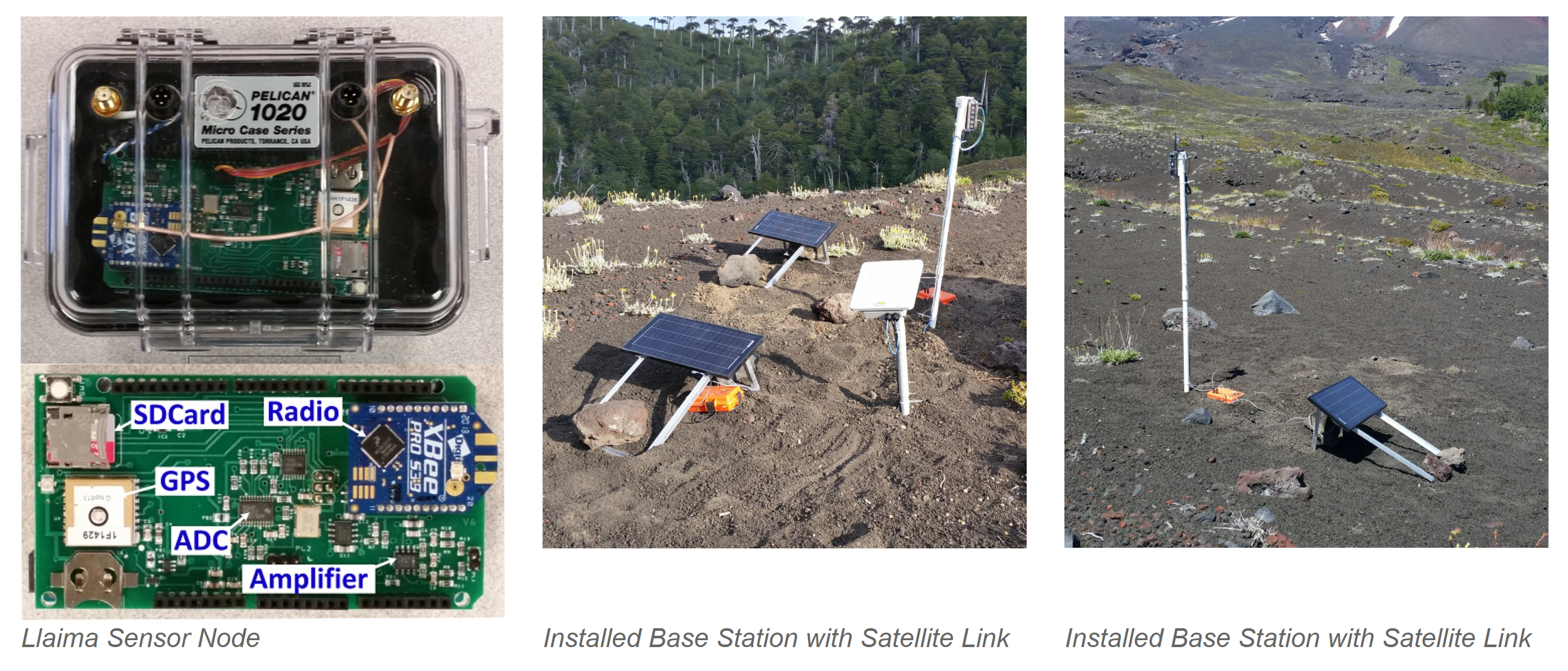
For communication, a Digi International XBee-Pro 900HP 900 MHz RF module provides network communications. This module support DigiMesh network topology with a RF data rate of 200Kbps. The maximum transmit power of this unit is 250 mW (24 dBm) and the receiver sensitivity is -101 dBm at 200Kbps. 900 MHz was chosen over 2.4GHz due to the reduced signal absorption in heavily wooded areas. The manufacturer claims the unit is capable of a line of sight range of 6.5 km with a 2.1 dB dipole antenna. This radio provides sufficient capability to allow a large number of nodes to exchange short messages, i.e. position information and event detection results. A GlobalTop Technologies, Inc. MTK3339 GPS chip provides geolocation information and global time along with a low jitter (less than 10 ns jitter) 1 pulse per second signal. This signal is used to synchronize the internal processor clock to global time. To mitigate the increased power consumption, control circuitry was included allowing the GPS chip to be powered down. A small coin battery is used to maintain the GPS memory during power down to allow quick restart when power is reapplied. To power the nodes Sealed Lead Acid (SLA) batteries were chosen. While not necessarily having the highest energy density, SLA's have certain advantages over other choices. They are inexpensive, commonly available even in third world countries, easy to transport, operate over a wide temperature range and survive large numbers of charge/discharge cycles.